Monday, May 16, 2016

Keeping busy ...Resort pool, Pahrump Valley Museum, bike ride and quick trip to Las Vegas

Since my last post we haven't had a chance to go back to Death Valley NP but we've been keeping busy. It's been very hot lately, like 97 degrees, here in Pahrump, NV. Not exciting things but helping us pass the time before we travel back to the Midwest to see our granddaughter graduate high school and bring her back with us to see a couple of the National Parks in UT. We've been to the pool here at the RV park a few times.


Which is pretty spectacular with the waterfall and all. Lots of lounge chairs, umbrellas and some shaded areas. It's pretty quiet now too with more folks gone for the summer. The water and breezes help with the heat recently. We also were able to ride our bikes on the road next to the park. Since we're out of town a ways the roads around here are less traveled. Good for biking. We diverted from the main road into a couple of small subdivisions. The homes are pretty spread out as you get out of town.

We had a chance to check out the local Pahrump Valley Museum too. If you'd like more information on the history of the museum, you can click HERE. The outside is very plain with some cool sculptures of children playing.


I thought these sculptures were really impressive. There is no admission fee to the museum. We just signed in and started looking around. Lots of antique irons, typewriters, construction equipment, mining tools, furniture and other miscellaneous artifacts.


We took our time enjoying some nostalgia. I can remember some of the old cameras and the bag phone. Technology has come along way in a short time.

There was a lecture going on in the back room when we arrived so when it ended we were able to view some history of the area related to underground nuclear testing. One hundred above-ground nuclear tests were conducted at the Nevada Test Site (NTS) between January 27, 1951, and July 17, 1962. - See more at: http://www.onlinenevada.org/articles/underground-nuclear-testing-nevada-test-site. On August 5, 1963, the Soviet Union and the United States signed the Limited Test Ban Treaty (LTBT), which prohibited nuclear tests in the atmosphere, under water, and in space. From that time, until the end of testing in 1992, nuclear tests at the NTS were conducted underground. - You can see more at: http://www.onlinenevada.org/articles/underground-nuclear-testing-nevada-test-site.

Drilling and mining equipment and other technologies had to be modified and improved upon to meet the needs of weapons tests. Underground safety protocols had to be implemented for all phases of the experiments. The shafts and tunnels where tests were conducted needed to be stemmed and sealed to prevent the escape of radioactive materials from the explosions.


Enlarge to read

Underground blasts would leave craters in the earth

Mining equipment to drill shafts

Shaft and drilling equipment photos

Short history lesson

In September 1992 the U.S. Congress passed legislation known as the Hatfield-Exon amendment for a nine-month moratorium on nuclear testing. As a result, the final nuclear tests conducted at the NTS were the tunnel test (code-named Hunters Trophy) on September 18 and the shaft test (code-named Divider) on September 23, 1992. On October 2, 1992, President George H.W. Bush signed the law containing the testing moratorium amendment. Test site tourists can visit the 157-foot tower built for a joint U.S.-United Kingdom test, code-named Icecap, one of three cancelled 1993 ground zero tests. On September 24, 1996, President Bill Clinton signed the Comprehensive Test Ban Treaty (CTBT), prohibiting nuclear weapons test detonations. The U.S. Congress has never ratified the treaty; however, the United States has maintained this cessation in nuclear testing.

Since we're heading back to the Midwest by way of Las Vegas and Allegiant Airway we thought we should check out where the airport was and possible long term parking. Especially with a huge truck and small parking spaces.

The drive from Pahrump. NV to Las Vegas is about 60 miles on SR 160 to I-215 that goes to the airport. Once we got to the airport we drove up a ramp to the parking garage and found that we would fit height wise. We were still concerned about the siddth though. We decided to head to the hotel we will be staying at after returning from the Midwest and see what there parking and possible shuttle opportunities might be.

We found out we could get a shuttle to the airport from the hotel upon leaving Las Vegas. That lead us to make a reservation at the hotel the day before our flight. They would shuttle us to the airport but we will have to take a taxi back after our trip. Yes, it's an extra night's stay but much more convenient and it would have cost is $16/day at the long term parking anyway. We don't have to get up as early to get to the airport and we can keep the truck parked there at the hotel for free until we get back.

That was a relief. After making those reservations we drove through part of the downtown strip on Tropicana Dr. and saw a couple of iconic hotels.


It was really a quick trip through the downtown. Lots of traffic and hustle and bustle. Our reasoning for doing this is when we get back from the Midwest we have tickets to see Michal Jackson One - Cirque De Solei ant the Mandalay Bay Convention Center. Now we have all our plans in order for our trip from and to Las Vegas.

Then we thought while we're here let's go to Hoover Dam. Never been there so why not? It was another 30 minute drive on I-15 to I-215 then onto SR 93 through Boulder City. NV. We turned off at the Mike O'Callaghan/Pat Tillman Memorial Walkway Bridge for viewing the dam. Spectacular view from there. As you walk out onto the bridge the dam comes into view on the left.


Glenda had to walk along the inner edge due to fear of heights

Yeah...it's pretty high

Quite an engineering feat to build

Huge pylons anchored into bedrock


Again this was just a quick view of the dam. We didn't even go down to drive across it either. Next time in the area we'll take more time. It was getting late and we still wanted to check out Lake Mead.

Lake Mead is just back down the road from Boulder City. WE made the turn off and checked out the RV campground. They have full hook ups some lake view sites and standard sites with limited lake views. Rates run from $35 to $55/night depending on the site and view.

We drove along the lake to Booulder Beach in the park and gound out why they call it Boulder Beach. Not an sand and lots of rocks(boulders?). People were still swimming and some sitting in chairs near the water.


Maybe we're too picky but not a beach I would probably go to if we were to stay in the RV park there. The views from the campground were nice since they sit up higher back from the water. You get a goo perspective of the lake.

We headed back to Pahrump with a stop outside Vegas for some dinner at In and Out Burger. Tasty sandwiches and fries. Quick service and made to order.

See we have been busy and getting some details taken care of. So very much looking forward to seeing family and bringing Jasmyne back with us. I've been reading some RV friends blogs that are already in UT hiking and sightseeing and they're really making envious. All I can  say is we'll be there soon.


Wednesday, May 11, 2016

Ash Meadows NWR and first visit to Death Valley

After getting set up in the new RV Resort and yes, this is an RV resort compared to Twenty nine Palms. We ventured out the first day to Ash Meadows NWR about 18 or 30 miles depending on which way you want to enter the refuge. We took the first entrance(south entrance) off Bell Vista Rd from Pahrump, NV. We found out right away it would have been better to go the extra miles around the refuge and enter at the west gate as the road was total washboard surface for several miles. It took for ever to get to our first stop called Point of Rocks. There is a nice boardwalk that leads to a pool of crystal clear water called King's Pool. The pool contains some very rare pupfish. There are several species of these fish in the refuge. They're difficult to see because they're only about 1/2 to 1 1/2 inches long. Even in the clear water.

They are thought to be the remainders of a large ecosystem of fish species that lived in Lake Manly, which dried up at the end of the last ice age leaving the present day Death Valley. The pupfish is adapted to shallow, hot, saline water with year-round above-ground flows, but tolerant of a very wide range of temperatures (0–40 °C (32–104 °F)).

Enlarge the photos for better viewing


Of course the area is surrounded by mountains which probably is why they call it Point of Rocks.


After some photo taking and watching the fish, we headed on to the Visitor's Center and the Crystal Springs Interpretive Boardwalk. The Visitor's Center is about a year old with nice displays and information about the area and the refuge. After getting our NP Passport Book stamped and dated we then took the walk on the boardwalk, which is about a 9/10 of a mile walk. Very wheelchair accessible too. It was very interesting seeing the diversity of the landscape in the desert. It's a amazing what a little water will do.


The volunteers were very friendly and told us we should drive to Devil's Hole to see where the only species of pupfish in the world lives. So off we drove on another washboard road for about 2 miles to Devil's Hole. The area is an ongoing ecological project as they monitor the pupfish. The population ranges from 500 during breeding and as low as 200 at other times of the year. They are very protected with fencing and cameras that monitor activity around the area. We found out that 3 youths had broken through the fence a couple days before and climbed down the hole and swam in the water. Unfortunately a few of the pupfish died due to this disturbance.


It's about 500 feet to the bottom of Devil's hole. The fencing at the overlook is like a cage you look through. They are very serious about these fish. The desert pupfish is considered an endangered species. After taking in all these sights it was time to go and get some lunch so we took the long way out(a lot less rough) and headed back to Pahrump.

We knew it was going to be getting hotter here in the next few days, like in the mid to upper 90's(it was in the 70's at Ash Meadows) so we decided to make our first excursion to Death Valley the next day. It's about 90 miles to Furnace Creek Visitors Center. We found at Joshua Tree the entrance fee was $20 unless you want to get an America the Beautiful Pass for $80/yr. Well being a senior I had purchased the Senior Pass when I turned 62 which is a lifetime Pass for $10 and allows for free entrance to the National Parks. The same, of course, was true at Death Valley. What an incredible bargain.


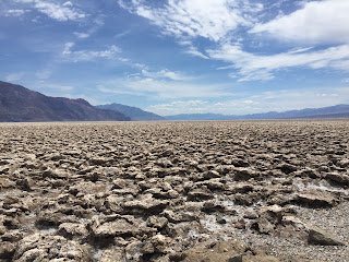
After getting our NP Passport Book stamped and dated we started driving toward an area called The Devil's Golf Course. Once we got there we could see why. The ground is very irregular and hard as a rock.


Almost an alien like landscape. So very beautiful but so very desolate and almost hostile feeling.

After some photos and a shameless selfie we continued our tour to the lowest place in the US, Badwater Basin Salt Flats. The salt flats in Badwater Basin cover nearly 200 square miles, and are among the largest protected salt flats in the world. Salt flats are too harsh for most plants and animals to survive, yet are quite fragile. The crystals are very delicate and easily crushed and the thin upper crust of salt can break through to the mud layer below, leaving tire tracks and even footprints.

I found out that Sodium Chloride—better known as table salt—makes up the majority of salts on Badwater Basin. Other minerals found there include calcite, gypsum, and borax.

The Badwater Basin is 282 feet BELOW sea level. There is a sign on the mountain next to the basin that shows you where sea level is compared to where you are.


In the middle left of the photo on the mountain is the sea level sign.

Enlarged sea level sign

This was an incredible place to visit and extremely popular. We felt like foreigners with all the people from different countries that were there. Anyway the Salt Flat was beautiful and eerie at the same time. I made sure to kneel down in an area where no one had walked and wet my finger, touched the ground and took a taste of the salt. Yes, it was like table salt.


What a wonderful experience. The Salt Flat viewing area is about 1/4 to 1/2 mile out into the basin but well worth taking the stroll. Such a unique formation of land. The Badwater Basin also holds the record for highest temperature at 134 degrees but as the sign says "It's a DRY heat". HaHa.


We were there at about 2 pm and even though it was only in the 70's back in Pahrump, the temperature measured over 90 in the basin. Fortunately there was a little cloud cover that made it more bearable. After about 30 - 40 minutes viewing and reading about the basin we started back home.

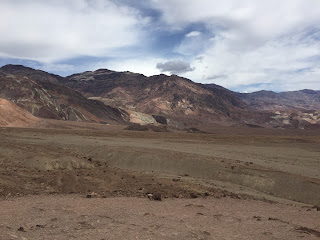
We did take a short side trip on Artist Drive. The face of the Black Mountains along Artist's Drive is made up of the multicolored rock of the Artist Drive Formation. Areas of pink, green, purple, brown, and black rock debris drape across the mountain front, providing some of the most scenic evidence of one of Death Valley's most violently explosive volcanic periods.


The photos do NOT do this area justice. The road itself was curvy, twisty and full of amazement around every curve.


A sign at the entrance of the road indicates No vehicles over 25 feet long should enter and after some of the curves we went around it was very obvious.

It was a wonderful day and there are still areas we plan to explore before we leave the area and head to UT. More adventures to come.